on the edge

a road trip around the perimeter of the contiguous US, documented. and all my other road trips.

Pages

  • Home
  • about the EDGE project
  • On the Edge Art Album
  • 2014 EDGE journal
  • Trip Photos
  • AAA list
  • southwest A-Z challenge
  • ALL MY LINKS | contact
  • Art Newsletter
Showing posts with label map. Show all posts

6.30.2024

Cross Canada (and Diagonally Home) Road Trip Done!

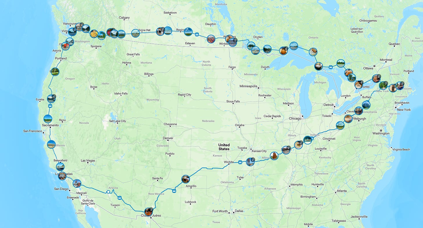
This is my route as logged into the Find Penguins app. (I’m still editing it, adding more photos). Here’s the link to view the entries.

7870 miles, 2 days north, 7 days across Canada, [8 days doing non road trip activites], 6 days westbound.


Next, I will work on a more detailed analog travel journal, with maps and ephemera.

I’ll use a format similar to journals I created in 2014 and 2009. (Did I make one in 2019? Not sure!) I blogged the 2014 trip and book in my Patreon. (In reverse order, link to first post) For 2024, I’ll be blogging my journey on several sites, as an experiment.


Years ago, I had the grand idea to circumnavigate Canada, the way I did the US in 2014. I was going to include Alaska, the one US state I have yet to visit.
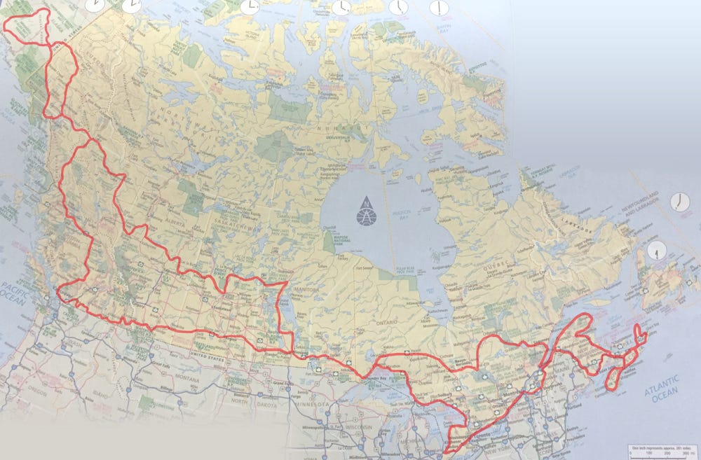
Looking at that map this January kind of freaked me out. I couldn’t wrap my head around doing the whole route. I scaled it down to something more manageable, just the part between Sumas, BC (north of Bellingham, WA) across to the Thousand Islands border crossing (north of Watertown, NY). And I pretty much avoided big cities (Vancouver BC, Toronto ONT).

Every week, I’ll go into detail about each day [except the 8 days in upstate NY].


While you wait for next week’s first installment - Los Angeles to Weed, CA - get previews on FindPenguins.

Posted by Anne M Bray at 8:21 AM No comments:
Email ThisBlogThis!Share to XShare to FacebookShare to Pinterest
Labels: Canada, Canada 2024, FindPenguins app, map, road trip recap, road trips

6.14.2021

Most of My Road Trips, Stitched

It's been WAY too long since I've been on a road trip!

I'm happy to say that I'll be making a quick drive up to San Francisco this coming Saturday.
Woohoo!

One of my stuck-at-home projects was to start stitching all my road trips on a dish towel sized North American map. 

I worked up the map in Illustrator, using a Photoshopped denim scan and vector maps purchased from iStock. I had it printed by Spoonflower in cotton twill.

This is a work in progress.
I want to include my planned circumnavigation of Canada in 2024!

I am also still missing some past road trips - the ones where I didn't keep good records and am having trouble remembering where I went. In addition, I'm not including any trips to just San Francisco. Too many!

The trips inventory:

  • fall 1974 one way [ow] not yet stitched
  • summer 75 round trip [rt] not
  • winter 75/76 rt not
  • summer 76 rt not
  • winter 76 ow not
  • winter/spring rt 82 yellow
  • fall 82 ow not
  • winter 93 rt white
  • summer 94 rt very dark indigo
  • spring 95 rt lt green
  • spring-fall 96 rt hot pink
  • winter 96/97 rt light pink
  • fall 99 rt not
  • summer 2000 rt orange
  • fall 09 rt rust
  • spring 14 light blue
  • summer 15 emerald
  • summer/fall 21 rt tbd
  • spring/summer 24 rt tbd

    Some housekeeping for those of you receiving these (rare) posts by email:
    the current service will stop sending posts at the end of July. If you would click through to the blog and sign up again with the new service, you'll stay in the loop! Thanks!

    Posted by Anne M Bray at 3:02 PM No comments:
    Email ThisBlogThis!Share to XShare to FacebookShare to Pinterest
    Labels: embroidery, iStock, map, north america, road trips, spoonflower

    7.28.2017

    Destination Seattle!

    I have been offered the opportunity to accompany a friend on a drive north the second week of August. Yeah!
    Planning is now kicked into fifth gear!

    Updates and posts from the road most likely to transpire on Instagram @annembray.
    It's a rare instance where I'll be more a passenger than a driver, so who knows WHAT I'll be up to.
    Posted by Anne M Bray at 6:05 AM No comments:
    Email ThisBlogThis!Share to XShare to FacebookShare to Pinterest
    Labels: I-5, map, Seattle 2017

    7.22.2015

    Hitting the Road

    I'm making my way up to Vancouver, BC for a fashion blogger meetup!

    I leave this morning, taking I-5 all the way up.
    Instagram is the best way to catch my antics during the trip.
    Posted by Anne M Bray at 4:55 AM No comments:
    Email ThisBlogThis!Share to XShare to FacebookShare to Pinterest
    Labels: map, route

    3.26.2014

    Funding is at 25% WooHoo!

    GIFTED/ LINKS/
    Thank you everyone that has donated to my IndieGoGo campaign!!! This morning, I went over the $2000 mark. Very exciting!

    I've been doing a "miles for $$" graphic over on the campaign (in lieu of a video, which I never finished). Today, I'm past southern Texas on the $$ map and couldn't be happier.

    There are 24 days left to donate. No amount is too small!

    OK, back to packing. Less than 24 hours until departure. Eeeeek!
    Posted by Anne M Bray at 8:21 AM No comments:
    Email ThisBlogThis!Share to XShare to FacebookShare to Pinterest
    Labels: crowdfunding, IndieGoGo, map

    3.01.2014

    A Roadtripper's Mobile Bookshelf

    PURCHASED/ GIFTED/ LINKS/ 
    Last night I got going entering some of my road-themed books into Goodreads.
    No, none of these, yet.
    It could have sworn I had The Art of Pilgrimage, by Phil Cousineau but I couldn't find it.

    Then, while shooting the above photo, I remembered that I'd put some road trip books on a special Road Trip Project shelf.
    Eureka! Found, and added to my "take with" pile:
    Since I'm driving, I can schlep lots of "stuff".
    List, with links and comments

    • Where Chefs Eat, by Joe Warwick
    I gave this to Severo, my partner in gluttony. He'll let me borrow it.
    • Where the Locals Eat, by L. Lee Wilson Purchased pre-Yelp. It's ©1998.
    • The Food Lover's Handbook to the Southwest, by Dave DeWitt Sensing a trend yet? I got this in 1992. I have used it extensively.
    • The Creative Habit, by Twyla Tharp Thought this would be good to read again.
    • Ghost World, by Daniel Clowes Wild card! I won't yet tell you why I'm taking this.
    • The Way of the Traveler, by Joseph Dispenza This was on the same shelf as The Art of Pilgrimage
    • The Mindful Traveler, by Jim Currie Currently reading
    • The Pacific Northwest, Insight Guides I have the 1989 edition. Absurd to take it?
    • Roadside America
    I have two copies of this, it's so entertaining. They also have a website. And an App.
    • Eat Your Way Across the U.S.A., by Jan and Michael Stern Sure, don't mind if I do!
    • 500 Things to Eat Before It's Too Late, by Jan and Michael Stern
    • Roadfood, by Jan and Michael Stern The classic original.
    • Road Trip USA, by Jamie Jensen This will be helpful on US2, the northern perimeter. She's written many other more specific guides, like one for New England. Maybe I'll get the Kindle edition.
    • U.S.A. & Canada, Travellers Survival Kit Picked this up for $1.00. Old ©1993
    • Rand McNally Pocket Size Atlas
    So cute. Usefulness debatable. I've got my AAA maps, my iPhone, and Siri.

    Any books (or Apps) that you can recommend?  
    Please, not Blue Highways. I've read it and it annoyed the heck out of me. I think Least-Heat Moon writes too elaborately, not for narrative flow, but to let us all know how "learned" he is.
    Posted by Anne M Bray at 4:31 PM 3 comments:
    Email ThisBlogThis!Share to XShare to FacebookShare to Pinterest
    Labels: book, enid, food, guide, map

    3.05.2013

    Mapped: FL > SC

    LINKS/
    Florida to South Carolina is going to take 4 days, according to Roadtrippers.com, a site I just read about in the LA Times. [Above is a composite of the 4 separate legs, which is why it looks a bit strange].

    I thought I'd give the site a try, since I made such a hash of my Google map seen on the previous post. Roadtripper also uses Google maps, so I was in a familiar space (having already mapped these parts TWICE already). You enter your Start and Destination (just like Google) and your route gets plotted the quickest way possible (just like Google), typically on Interstates. I found it easier to make and move extra markers off the Interstates to the US highways in Roadtripper. It was also MUCH easier to smooth out any circling tangles that sometimes occured (ALWAYS an issue when I use Google).
    reenactment achieved in Google Maps in under one minute
    There are more features in the site, which I'll explore further later (local attractions, eats, accommodations, etc). First, must map!

    Notice that I broke one of my "rules" of not doubling back on any roads. "But it's Key West!"
    I've never been to Key West, I've been curious about that stretch of US1 that threads across the keys, and when will I be again driving so close? Never, most likely. Rules are made to be broken, right?
    Posted by Anne M Bray at 6:46 AM 3 comments:
    Email ThisBlogThis!Share to XShare to FacebookShare to Pinterest
    Labels: eastern EDGE, Florida, Georgia, google maps, map, on the edge US 2014, roadtripper, route, South Carolina, southern EDGE
    Location: Florida, USA

    1.28.2013

    Mapped: Southern EDGE

    [click to see bigger]
    I finally sat myself down with Google Maps (yet again) to start plotting my route. One can only route out 26 stops (for directions, mileage and estimated duration), so I stopped at Panama City, FL.
    I'd made a previous map in 2011 which got messed up (as often happens with my Google maps. In fact, I managed to erase all my work above. ARGH! Thank goodness I made a screen shot that included my plot points! I will have to do it YET AGAIN). Anyway, as I was saying, along with being messed up, the 2011 map was plotted with the plan of driving at State highway level. VERY INTIMIDATING!
    Look at Connecticut:
    CT wore me out. I couldn't face the rest of New England after CT.
    Really. Plotting CT made me realize that THE TRIP WOULD TAKE FOREVER!
    So I let it rest for a couple of years!

    Going as local as State highways is much saner.
    Except when I get to Maine. We will avoid that subject for now. Denial can be a blessing.
    In fact, I was surprised that from my home to Van Horn, TX, it's pretty much the same highways that I would take on any road trip (if I were to go via San Diego, that is).
    I even know how long that section will take! 2-3 days!
    Not so scary after all! (She says with optimism).
    Next: Florida...

    Posted by Anne M Bray at 6:18 AM No comments:
    Email ThisBlogThis!Share to XShare to FacebookShare to Pinterest
    Labels: Connecticut, map, on the edge US 2014, route, southern EDGE

    1.07.2013

    Greetings From: 90066

    LINKS/ 
    Big new project! [originally posted here on 6/10/10]

    I've told some of you about the Big Road Trip that I'm plotting for 2014. I'm calling it "On the Edge" and just now registered the domain on-the-edge.us. After I figure out the "Name Server" stuff, I'll have linkage.
    I plan to circumnavigate the US by car on State Highways as close as possible to the perimeter of the contiguous 48 US states. (I might actually have to start earlier, since I want to be in South Carolina in March when my Mom is there). I'm going to crowd fund it on IndieGoGo and need to figure out what kind of artwork I'm going to generate out on the road for donor rewards and such.

    The California coast provides a good stretch of highways that are conveniently close to my abode, so I'm using them to perform experiments. Part of my concept is to tape the entire journey out the passenger side window. I obtained a cheap webcam that I can attach to my laptop to directly download the video to my hard drive. I gave it a test run when we drove to Encinitas a few weeks ago.
    Reenactment of setup
    (hope it's obvious webcam not on!)
    On Friday, I was stuck with a long Dr visit wait and took along the laptop to try to see what art I could come up with. I scanned quickly through the footage and found this bit with a slice of the Pacific:
    The screen grab from the video
    First idea: sketching from screen grab.
    Verdict: too drab, needs color.
    Next idea: Repaint image in Corel Painter
    Verdict: LIKE!
    Note to self: next time, attach the Wacom tablet -- finger twiddling on laptop is DIFFICULT
    I feel like I'm off to a good start.
    Next, I need to spray paint the webcam black to cut down on window reflections and make some kind of rigid platform to hold the laptop.
    I'll try it out on Oxnard to Santa Monica on PCH/CA 1. Stay tuned!
    Posted by Anne M Bray at 9:18 PM 2 comments:
    Email ThisBlogThis!Share to XShare to FacebookShare to Pinterest
    Labels: concepts, digital painting, gear, map, process, sketch
    Location: Los Angeles, CA 90066, USA
    Home
    Subscribe to: Posts (Atom)

    Translate

    connect!

    subscribe

    Get new posts by email:

    About Me

    My photo
    Anne M Bray
    View my complete profile

    Search This Blog

    Blog Archive

    • ▼  2024 (2)
      • ▼  July (1)
        • Oh Canada! 2024 notes
      • ►  June (1)
    • ►  2021 (1)
      • ►  June (1)
    • ►  2019 (14)
      • ►  November (1)
      • ►  October (3)
      • ►  August (3)
      • ►  July (1)
      • ►  June (2)
      • ►  May (1)
      • ►  February (1)
      • ►  January (2)
    • ►  2018 (8)
      • ►  May (6)
      • ►  April (1)
      • ►  February (1)
    • ►  2017 (6)
      • ►  August (3)
      • ►  July (1)
      • ►  March (2)
    • ►  2016 (5)
      • ►  June (1)
      • ►  April (1)
      • ►  March (3)
    • ►  2015 (60)
      • ►  November (2)
      • ►  October (4)
      • ►  September (4)
      • ►  August (4)
      • ►  July (6)
      • ►  June (3)
      • ►  May (3)
      • ►  April (28)
      • ►  March (5)
      • ►  February (1)
    • ►  2014 (44)
      • ►  November (1)
      • ►  September (2)
      • ►  August (1)
      • ►  July (2)
      • ►  June (4)
      • ►  May (11)
      • ►  April (17)
      • ►  March (5)
      • ►  January (1)
    • ►  2013 (6)
      • ►  December (1)
      • ►  October (1)
      • ►  April (1)
      • ►  March (1)
      • ►  January (2)

    my other blogs

    • pattern recognition -- surface design
      A to Z Blogging Challenge 2026: A-Z Index - The 2026 A-Z Fluevog footwear collection You are invited to the *Inlinkz* link party! Click here to enter The A to Z Challenge is held every April. The chal...
      2 months ago
    • SpyGirl, my fashion blog
      Good Buy/ Goodbye: Mini Skirts - I had a sketch/ journal session with the theme Sketch Favorite Things. I chose mini skirts, since I knew that was the theme for Shelbee and Nancy's Good B...
      11 months ago
    • Anne’s Substack
      That Time a Hitchhiker Stole My Wallet - I-70 in Utah.
      11 months ago
    • the glutton's progress
      Elote Off the Cob - Mexican street corn but make it easy to eat. Adapted from Gimme Some Oven Elote Off the Cob *INGREDIENTS* - 1 tablespoon butter or olive oil (butter...
      1 year ago
    • A-Z trucks (mostly)
      A Photo a Week Challenge: Playtime - Nancy’s Photo a Week prompt is Playtime this week, and I’m featuring some photos of us playing around amidst the street mosaics found in the South Street P...
      3 years ago
    • sketches and impressions
      The Kids Play Petty - Sketched at a Petty Tribute gig last night. The kids are all right! Frieda's Roses BandCamp link Alexa T Rhodes Link to Event
      6 years ago
    • dessert safari
      Sfogliatelle Adventure with Karen - Karen and I had a meet-up in her new refurbished kitchen and Karen suggested that we make Sfogliatelle, apparently the symbolic dessert of Naples, Italy. ...
      8 years ago
    Show 5 Show All

    Labels

    • 2015 A-Z challenge (25)
    • Arizona (14)
    • California (32)
    • Florida (4)
    • Georgia (1)
    • Louisiania (6)
    • Maine (3)
    • Massachusetts (1)
    • Mississippi (2)
    • Nevada (1)
    • New Mexico (6)
    • New York (1)
    • North Dakota (1)
    • Oregon (2)
    • Rhode Island (2)
    • South Carolina (1)
    • Texas (24)
    • Utah (1)
    • Washington (2)
    © 2024 - 2013 anne m bray ALL RIGHTS RESERVED. Awesome Inc. theme. Powered by Blogger.